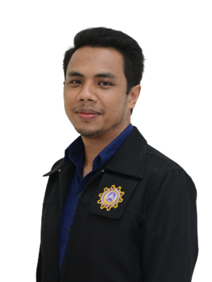
ดร. สุรเชษ ศรีนารา
ตำแหน่ง อาจารย์
อีเมล surachet.sr@up.ac.th
หมายเลขโทรศัพท์ 3384
Education:
| 2018-2025 |
Ph.D. (Geomatics) Department of Geomatics National Cheng Kung University |
|
Tainan, Taiwan
|
|
| 2012-2014 |
M.Eng. (Survey Engineering) Department of Survey Engineering Chulalongkorn University |
|
Bangkok, Thailand
|
|
| 2007-2011 |
B.Eng. (Civil Engineering, Second Class Honors) Department of Civil Engineering Naresuan University |
|
Phitsanulok, Thailand
|
Area of Interest:
| - INS/GNSS Integration System |
| - Mobile Mapping System (MMS) |
| - Multiple Sensor Fusion System |
| - Localization / Navigation |
| - Adaptive POS Covariance Estimation for LiDAR Matching |
| - Creation and Verification of High-Definition Maps |
| - LiDAR/Visual-SLAM |
| - Enhancing PNT Capabilities for Autonomous Vehicle and Intelligent Mobility Applications |
| - Object / Change Detection |
| - Establishment of Reliable Reference System for Autonomous Vehicle Development and Applications |
Grants and Awards:
| June, 2025 | Best Paper Award | Mobile Mapping Technology (MMT) 2025 |
|
Xiamen, China
|
|
| October, 2024 | Merit Award | 2024 MATLAB® & Simulink Competition |
|
Taipei, Taiwan
|
|
| September, 2023 | Best Presentation Award | ISPRS Geospatial Week 2023 |
|
Cairo, Egypt
|
|
| September, 2022 | Best Student Paper Award | ION GNSS+ 2022 |
|
Denver, Colorado, USA
|
|
| September, 2021 | Oustanding Paper Award of the Year | National Cadastral Survey |
|
Taipei, Taiwan
|
|
| December, 2013 | Best Paper Award | GeoInfoTech |
|
Bangkok, Thailand |
|
Publications:
|
1.) S. Srinara, K. -W. Chiang, M. -L. Tsai, Y.-F. Chang, A. Ritthiphan, and C. Satirapod, “An Integrated Approach to Enhance Navigation Estimation Capabilities for Land Vehicle Applications Using HD Maps-Aided INS/GNSS/Low-Cost LiDAR Fusion Engine,” The 13th International Symposium on Mobile Mapping Technology, Xiamen, China, June 19-22, 2025.
|
|
2.) S. Srinara, K. -W. Chiang, A. Ritthiphan, and C. Satirapod, “Performance Evaluation of HD Map-Aided Localization for Land Vehicles in Underground Parking Using Integrated INS/GNSS and Low-Cost LiDAR,” Engineering Journal, 2025.
|
|
3.) K. -W. Chiang, S. Tsai, J.-A. Chen, S. Srinara, M. -L., Tsai, C.-Y. Hsieh, J.-Y. Hung, C. Satirapod, and N. El-Sheimy, “AI-Driven Mapping System for Smart Parking Management Applications Using an INS-GNSS-Solid-State LiDAR-Monocular Camera Fusion Engine Empowered by HD Maps,” in IEEE Open Journal of Intelligent Transportation Systems, 2025.
|
|
4.) K. -W. Chiang, S. Srinara, Y. -T. Chiu, M. -L., Tsai, C. Satirapod, N. El-Sheimy, and M. Ai, “Creation and Verification of High-Definition Point Cloud Maps for Autonomous Vehicle Navigation,” in IEEE Internet of Things Journal, 2024.
|
|
5.) Tsai, M.-L., Chiang, K.-W., Hsieh, C.-Y., Lin, S., Srinara, S., and Chiu, Y.-T., "Alternative GCP Sources for Accurate HD Map Production," Int. Arch. Photogramm. Remote Sens. Spatial Inf. Sci., XLVIII-1/W2-2023, pp. 855–860, 2023.
|
|
6.) Lu, Y.-E., Chiang, K.-W., Tsai, M.-L., Chiu, Y.-T., Srinara, S., Wu, T.-C., and El- Sheimy, N., "An Evaluation of Solid-State Lidar For Localization and HD Point Cloud Mapping," Int. Arch. Photogramm. Remote Sens. Spatial Inf. Sci., XLVIII-1/W2-2023, pp. 841–847, 2023.
|
|
7.) Srinara, S., Chiu, Y.-T., Chen, J.-A., Chiang, K.-W., Tsai, M.-L., and El-Sheimy, N., "Strategy on High-Definition Point Cloud Map Creation for Autonomous Driving in Highway Environments," Int. Arch. Photogramm. Remote Sens. Spatial Inf. Sci., XLVIII-1/W2-2023, pp. 849–854, 2023.
|
|
8.) Chiu, Y.-T., Srinara, S., Tsai, M.-L., Chen, J.-A., Chiang, K.-W., and El-Sheimy, N., "Evaluating Navigation Performance of Elastically Constructed HD Map with Multi-Sensor Fusion Engine System," Int. Arch. Photogramm. Remote Sens. Spatial Inf. Sci., XLVIII-1/W2-2023, pp. 799–805, 2023.
|
|
9.) Chen, J.-A., Srinara, S., Chiu, Y.-T., and Chiang, K.-W., "LiDAR Matching Strategies for HD Point Cloud Map Generation in Urban Area," Int. Arch. Photogramm. Remote Sens. Spatial Inf. Sci., XLVIII-1/W2-2023, pp. 785–790, 2023.
|
|
10.) K. -W. Chiang, S. Srinara, S. Tsai, C. -X. Lin and M. -L. Tsai, “High-Definition-Map-Based LiDAR Localization Through Dynamic Time-Synchronized Normal Distribution Transform Scan Matching,” in IEEE Transactions on Vehicular Technology, vol. 72, no. 6, pp. 7011-7023, June 2023.
|
|
11.) Chiang, K., Chiu, Y., Srinara, S. et al., "Performance of LiDAR-SLAM-based PNT with initial poses based on NDT scan matching algorithm." Satellite Navigation 4, 3(2023).
|
|
12.) Srinara, Surachet, Chiu, Yu-Ting, “Adaptive Covariance Estimation of LiDAR based Positioning Error for Multi-Sensor Fusion Scheme with Autonomous Vehicular Navigation System,” Proceedings of the 35 th International Technical Meeting of the Satellite Division of The Institute of Navigation (ION GNSS+ 2022), Denver, Colorado, September 2022, pp. 1650-1664.
|
|
13.) S. Srinara, S. Tsai, C. -X. Lin, M. -L. Tsai and K. -W. Chiang, “Reliable Evaluation of Navigation States Estimation for Automated Driving Systems,” 2022 IEEE Intelligent Vehicles Symposium (IV), Aachen, Germany, 2022, pp.1765-1773.
|
|
14.) Chiu, Y.-T., Srinara, S., Tsai, M.-L., and Chiang, K.-W., "Improvement of LiDAR-SLAM-based 3D NDT Localization Using Fault Detection and Exclusion Algorithm," Int. Arch. Photogramm. Remote Sens. Spatial Inf. Sci., XLIII-B1-2022, pp. 189–195, 2022.
|
|
15.) Srinara, S., Chiu, Y.-T., Tsai, M.-L., and Chiang, K.-W., "High-Definition Point Cloud Map-Based 3D LiDAR-IMU Calibration for Self-Driving Applications," Int. Arch. Photogramm. Remote Sens. Spatial Inf. Sci., XLIII-B1-2022, pp. 271–277, 2022.
|
|
16.) S. Srinara, C. -M. Lee, S. Tsai, G. -J. Tsai and K. -W. Chiang, “Performance Analysis of 3D NDT Scan Matching for Autonomous Vehicles Using INS/GNSS/3D LiDAR-SLAM Integration Scheme,” 2021 IEEE International Symposium on Inertial Sensors and Systems (INERTIAL), Kailua-Kona, HI, USA, 2021, pp. 1-4.
|
|
17.) Srinara, S., and Wongsuwan, A., (2017), "Test of GPS Horizontal Positioning Accuracy between Smartphone Apps, Handheld GPS and Geodetic Receiver," Proceedings of the 22nd National Convention on Civil Engineering, 18-20 July, Nakhon Ratchasima, Thailand.
|
| 18.) Srinara, S., and Satirapod, C., (2013), Optimization of GNSS Satellite Combination in Kinematic Positioning Mode with Aiding of Genetic Algorithm, Proceedings of the National Convention on Geo-informatics and Space Technology 2013, 25-27 December, Bangkok, Thailand. |
